Public Rights of Way
Great Bromley village has 23 public rights of way in the form of footpaths, bridleways and byways. These are listed below.
An interactive map of Public Rights of Way in Essex can be found here. Alternatively please refer to OS Explorer Map 184.
Essex County Council and local landowners are responsible for maintaining the rights of way and keeping them free from obstructions. However local volunteers also help to ensure that footpaths remain passable throughout the year.
The village has a Footpath Warden who monitors the rights of way and reports any problems to the County Council or landowners for action. Each year the Footpath Warden surveys and report on the state of the village's rights of way.
The parish is a member of Essex County Council's Parish Paths Partnership scheme.
Comments, suggestions or reports on our rights of way can be clerk [at] gbpc.org.uk (emailed) to the Footpath Warden via the Clerk.
Footpaths and descriptions
Footpaths map (click to open large image)
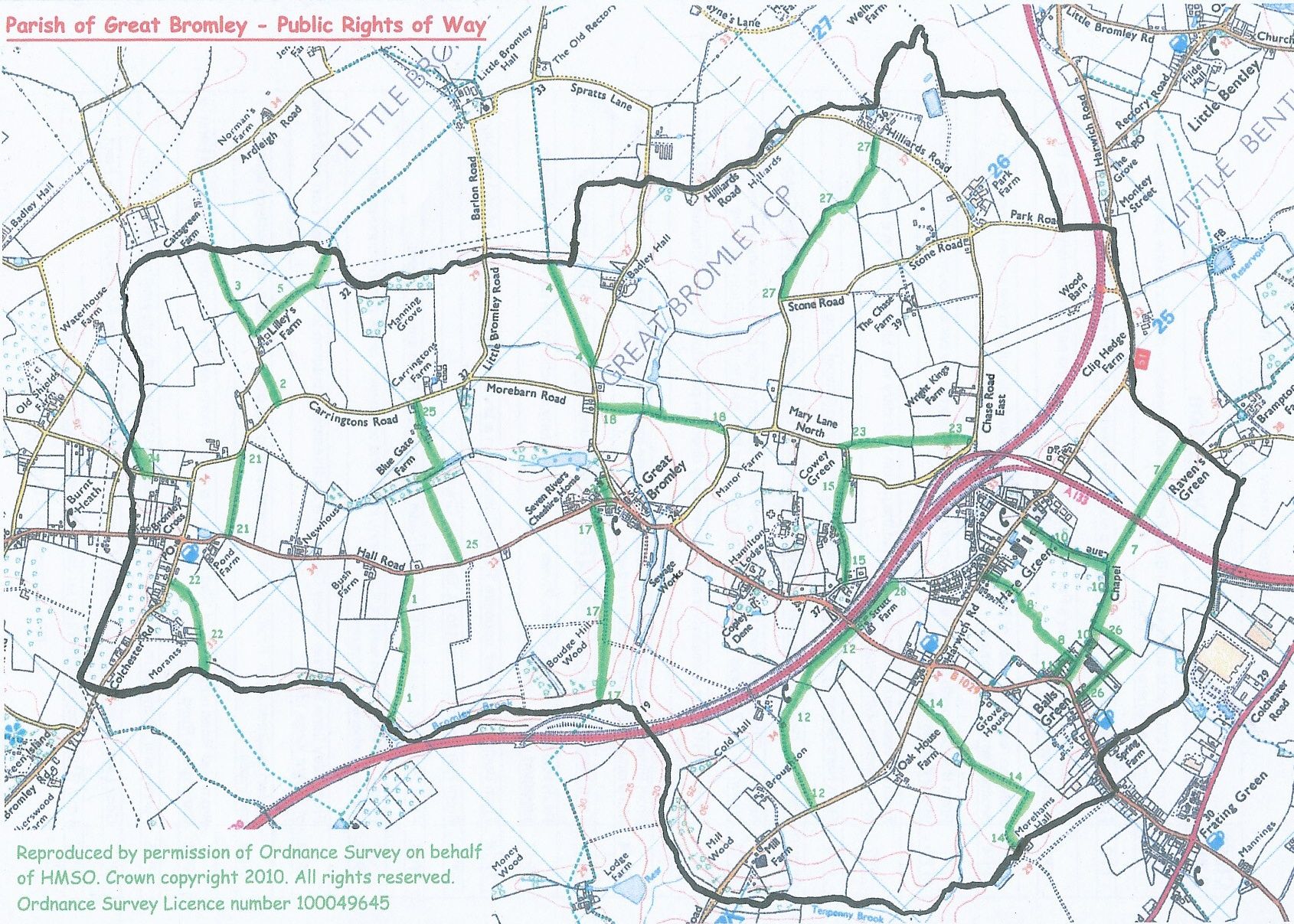
Parish of Great Bromley - Public Rights of Way
FP = footpath, BR = bridleway, BWY = byway
FP1: From road 200 yards south-east of Bush Farm in a south-westerly direction to the parish boundary vith Elmstead where it continues.
FP2: From the road south of Lilley's Farm in a southerly direction to Carringtons Road
FP3: From the road north of Lilley's Farm in a northerly direction to the parish boundary with Little Bromley where it continues
FP4: From the road south-west of Badley Hall in a north-easterly direction to the parish boundary with Little Bromley where it continues
FP5: From the road north of Lilley's Farm in an easterly direction to the parish boundary with Little Bromley where it continues
FP7: From the road north of Raven's Green at the parish boundary with Little Bentley in a westerly direction to its junction with Byway 10
FP8: From Hare Green by 'Portlands' in a southerly drrection to Chapel Lane
BYW1O: From Hare Green in a southerly then westerly direction to the road east of Methodist Chapel
FP11: Known as 'The Alley'. From the B1029 at the south-eastern corner of the boundary of the property known as 1 & 2 Chapel Row, in a northerly direction then east to the junction with FP8
FP12: From the B1029 in a westerly lhen south-westerly direction past Cold Hall to Elmstead Road east of 'The Hollies'
FP14: From Elmstead Road 200 yards west of 'Courthouse Inn' PH, in a southerly and westerly direction to Morehams Hall at the parish boundary
FP15: From Mary Lane North south-west of FP23 in a south-westerly direction to Back Lane West
FP17: From Hall Road east of 'Seven Rivers' in a south-westerly direction to the parish boundary with Elmstead where it continues
FP18: From Badley Hall Road, opposite 'Peace Cottages', in a south-easterly direction to Mary Lane North
FP2O: From Hall Road north-east to St. George's Church
FP21: From Hall Road, near Pond Farmn north-east to Carrinqtons Road east of Hazels Farm
FP22: From Colchester Road west of 'Cross lnn' PH, south and south-west to the parish boundary with Elmstead where it continues
FP23: From Mary Lane North at Cowey Green, in a south-easterly direction to Chase Road East south-west of Wright Kings Farm
BR24: Known as Green Lane. From Briar Road, north-east to the parish boundary with Ardleigh where it continues
FP25: From Hall Road north-west of 'Red House' in a general north-easterly direction via Blue Gate Farm to Carringtons Road
FP26: Furze Lane. From the road near Union Place, east and then north to its junction with BYW10
BR27: Cock Lane. From Stone Road north of The Chase, easterly to Hilliards Road north of Park Farm.
FP28: From B1029, opposite FP12. in an easterly direction to Back Lane East